|
The markings on the trails in the western Negev highlands have been freshly
painted and the 2004 edition of the Negev Highlands Hiking and Trail Map has
just come out. In honor of these two events, members of the ERETZ staff recently
set out on a hike in the area.
We wanted to start out on the
green-marked trail
descending into Makhtesh Ramon, one of the fascinating depressions in the earth,
caused largely by erosion, that are found mainly in the Negev and Sinai, and
hardly anywhere else in the world. Accordingly, we drove westward from Mitzpe
Ramon on the road that leads to Mt. Harif. We stopped the car in a small parking
lot, beside kilometer marker 12. Instead of the sign that used to point to the
beginning of the route, we found only a pile of earth that was blocking our way.
“We took down the sign,” Hanan Afriat, Israel Nature and Parks Authority (INPA)
ranger in the southern Negev highlands, told us apologetically. “This trail is
meant for hikers only. But there are people with jeeps who won’t take ‘No’ for
an answer. They drove on the trail and left terrible grooves in the ground. They
would get as far as the edge of the makhtesh, where you can’t drive any further.
On the way back to the road, they wouldn’t want to return via the same route,
and so they’d start to plow through the area. Add to that the grooves left by
vehicles chasing after smugglers and you end up with a devastated area.”
The INPA rangers not only removed the sign and blocked the trail with a pile of
earth. They also developed a special device consisting of two rows of thick
cables, which they drag over the ground to smooth it out a bit in order to
obscure the grooves left by the jeeps. This system is put into operation in the
month of October, a time when there are no annual plants on the surface. The
work is done in such a way that it doesn’t harm the shrubs in the area but only
“combs” them. It has to be done before the first rain, since the raindrops that
fall on the smoothed ground coagulate the dust and help remove the traces.
This operation is cosmetic and doesn’t repair the damage that was done, but it
does help to discourage jeep owners from entering the area. The smoothed ground
gives them the feeling that they are destroying a pristine place instead of
following in the tracks of their predecessors. Another way of restoring the area
to a more “natural” appearance is the digging of little depressions in order to
imitate the activity of the porcupines, which in summer make innumerable holes
in the ground in search of crocus bulbs.
The “green” trail climbs up a shallow channel that drains the gentle northern
slope of the Ramon Ridge on its way to the riverbed of Nahal Nitzana. Like many
channels of its kind, it is covered densely with desert shrubs such as white
wormwood and jointed anabasis.
The abundant vegetation and the remains of agricultural terraces attest to the
extensive agriculture that existed here in the Byzantine period. Every shallow
gorge was cultivated. The cultivation improved the condition of the soil in the
channels and now they are filled with desert plants that “remember” ancient
times.
The vegetation in the channels is the main means of sustenance for the
herbivorous animals that inhabit this area. Gazelles and ibexes have been here
from time immemorial and in 1984 the INPA reintroduced herds of onagers to the
Israeli wild, in Makhtesh Ramon. The onagers are doing well, have reproduced
nicely, and can now be found throughout the large expanse between Nahal Tzihur
and the Barnea Plateau (beside Shivta). The Negev highlands has a “resident”
herd numbering about 30 onagers. It makes do with food that nature offers, but
is aided by a water trough installed by
the INPA.
The channel in which we were
hiking was
strewn with droppings, and onager tracks could be seen in abundance. The length
of a mature onager’s hoof is 6 or 7 centimeters. We also saw many tracks of
young onagers, which were 4 centimeters long. Soon they will be followed by the
tracks of oryxes, when the INPA reintroduces the species to its biblical home.
The only animals around that don’t belong to the reserve are camels, used by
smugglers bringing goods from Egypt to the southern part of Mt. Hebron.
Down into
Makhtesh Ramon
Our trail met up with a trail marked in blue, which continued to our right, but
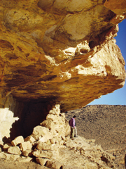
we continued on the green trail to the rim of Makhtesh Ramon. When we got there,
we made a little detour to the right, to a wall built beneath a long rock shelf.
Shepherds used to take shelter in the chamber formed by the wall.
Here, some 200 meters above the makhtesh floor, the view is breathtaking. We
could see the entire length of the makhtesh, all the way up to the Mahmal
Valley, Mt. Ardon, and the Ardon Valley. We were able to make out Mitzpe Ramon,
on the northern cliff of the makhtesh; we also saw Mt. Arod, a mass of black
basalt rising some 230 meters from the makhtesh floor.
It was time to go down into the makhtesh. The descent gently meanders and its
stones were cleared away long ago to create a passage for heavily laden camels.
On the makhtesh floor, the trail turns eastward, toward basalt hills, and enters
a small basalt crevice, known as the Canyon of the Prisms. The crevice’s walls
reveal beautiful exposures of basalt prisms, toothed peaks, and dark split rock
arrayed in little columns. The prisms incline slightly to the west, a phenomenon
that seems to indicate that the prisms formed during the flow of lava. In any
event, it’s a delightful place to stop for breakfast.
After exiting the Canyon of the Prisms and entering the expanses of the
makhtesh, the trail meets up with a black-marked dirt road that runs beside
Nahal Ramon, the riverbed that drains Makhtesh Ramon. Here we walked westward
(right) for nearly 2 kilometers, until we met up with a trail marked in red,
which climbs southward and leads up the southern cliff of the makhtesh.
Leaving the
Makhtesh
In the segment we were exploring, the southern cliff rises some 150 meters above
the makhtesh floor. Still, it’s not a bad climb, especially since it takes you
past red and purple sandstone rocks from the Lower Cretaceous epoch (144 million
years ago).
Moreover, in winter the slope is
festooned with wild rhubarb, a rare plant in Israel that grows only in the
western part of Makhtesh Ramon and in the Nahal Arod area, from a height of 700
meters and up. Each plant develops up to three large leaves, whose diameter,
after particularly rainy winters, can be as large as 70 centimeters – a very
strange sight in the desert. In spring, the plant blossoms with red flowers.
When summer begins, the leaves fall off and the plant endures the heat as a
thickened root deep in the ground.
The trail first runs along on the coxcomb, which marks the peak of the vertical
layers of the southern slope of the Ramon Ridge. Prior to the erosive activity
that formed the makhtesh, these layers climbed up to the top of the Ramon Ridge.
We were headed for Mt. Ido, situated about 1 kilometer away, and so we left the
slope of the ridge.
A trail with a “transparent” marking
(whose two white stripes flank an unpainted space rather than the usual colored
stripe) branches off from the red trail and climbs to the top of Mt. Ido
(959 meters).
Mt. Ido is a residual mountain, consisting of surviving rock from a plateau that
underwent erosion and geological upheaval. It is composed of white limestone
from the Eocene epoch, about 58 million years ago. The view is amazing. We could
see the northern cliff of Makhtesh Ramon, Mt. Ramon, and Mt. Harif. To the
south, we could see Mt. Arif, which contains two makhteshim, and rising behind
it, Mt. Karkom, which is famous for its rock drawings. To the east, we could see
Mt. Tzuri’az, Mt. Tzenifim, and all the way to Mt. Edom. To the west, we could
see the Lotz Cliffs, where we were headed.
To the Lotz Cliffs
From the top of Mt. Ido, the red trail descends to Nahal Arod and crosses it, in
order to reach the dirt road (marked in blue) that runs along the riverbed. We
turned right on the blue road and passed a campsite. Here, too, many wild
rhubarbs can be seen in winter.
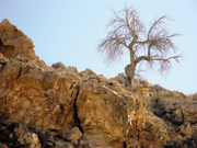
Not far from the campsite, we came upon Atlantic pistachio trees. Several
hundred Atlantic pistachios have survived in the Negev highlands. They are
centuries old and a few of them are huge, especially the ones that grow in large
channels, such as Nahal Arod and Nahal Lotz, which collect sizable amounts of
water. Others grow in rock fissures. They are smaller, but no less endowed with
the hardiness that enables them to continue to survive in the harsh conditions
of the Negev highlands.
After a walk of nearly 2 kilometers on Nahal Arod’s blue-marked dirt road, we
turned south (left) in a little channel containing a trail marked in black. The
trail took us on a gentle climb to the Lotz cliffs. In addition to the large
white broom bushes that prevail in the area, there are two big shrubs. One of
them is bladder senna, which has large yellow flowers. The other is Rhamnus
disperma, a densely tangled shrub with pointy branches. In Israel, this plant
grows in the Negev highlands and in the southern part of the Judean Desert.
The trail reaches the top of the Lotz Ascent, another lovely lookout point with
a view of Mt. Batur and the Hisun Valley; the high plateaus of Mt. Nes and Mt.
Sagi; Mt. Haspas, with Mt. Karkom rising behind it; and Mt. Arif, in which we
could see even the southern wall of the Large Makhtesh. Also visible is the
canyon of Nahal Ketziya, which drains into Nahal Arod and the Barak Plateau.
From there we followed the green-marked trail leading to Nahal Eliav. The
landscape was similar to the landscape in which we ascended, but the Atlantic
pistachios here seemed larger.
Perhaps because the descent took less effort, it was easier for us to discern
the dry stalks of the yellow asphodel and the Tulipa systola (tzvoni hamidbar –
“desert tulips” – in Hebrew). We could also see the erect stems of the Ferula
daninii (kelach danin – “Danin fennel” – in Hebrew), a plant known for its
cuplike appearance and endemic to the western Negev highlands and the Sde Boker
area.
In addition, we got a look at what is known as a fat sand rat, a creature that
can be as large as 17 centimeters long. It studied us for about half a minute
before fleeing into a burrow it had dug for itself in the shade of a large rock.
In the course of the hike, we had seen cut stalks of jointed anabasis, which the
sand rats had not yet managed to put into their burrows for consumption in a
place where they were less exposed to predators. Maybe they were waiting until
we passed.
The green trail leads down Nahal Eliav, but we went off to the right and up a
black-marked trail leading up a small ridge to the Nahal Lotz Ascent, which has
a red-marked trail. Three hundred meters later, we reachedthe riverbed. At the
meeting point with the excellent dirt road that leadsfrom the road that goes to
the Arod Ascent, the vehicle was waiting topick us up. Another nice day’s outing
in the Negev had come to an end. |