|
Every
time a new edition of a trail map comes out, I approach it with mixed feelings.
On one hand, I look forward to seeing additional trails that open up fresh
hiking possibilities. On the other, I’m afraid I might discover that trails I
happily hiked upon for many years have been sacrificed on the altar of
development.
As I
studied the latest Upper Galilee trail map, I noticed a change in the route of
the black-marked trail that leads down to Keren Bartot and Ein Tamir. “The
community of Hila expanded westward,” Dani Gaspar, coordinator of the Israel
Trails Committee, explained apologetically. “About two years ago, they built a
new neighborhood that covered the top of the trail. Israel Nature and Parks
Authority (INPA) ranger Sayid Hamud helped us re-route the trail and Keren
Kayemeth LeIsrael-Jewish National Fund (KKL-JNF) cleared the new segment and
added curbstones and stairs where necessary.”
But
that wasn’t the only change. Many hikers have been shocked to learn that the
INPA has shaven away the forest of oaks that enveloped Montfort Castle.
I
decided to take a 10-kilometer hike along the trail and get my own impressions
of the changes. Dani Gaspar accompanied me.
Keren Bartot
We
started walking down the black trail from its beginning. On our right was a
fence that ran along the perimeter of an agricultural field. The woods on the
left eventually gave way to fruit trees, among them a lone Syrian pear tree.
Some
say that at the beginning of summer, just when the tree’s nearly spherical
pears, up to 4 centimeters in diameter, have ripened, you can chew the fruit and
even swallow it, but the flavor is nothing to write home about.
The
trail then leads down to the shallow upper segment of the riverbed of Nahal
Bartot. A lovely wood grows in the gorge. Since it is in a spot that faces north
and is therefore less exposed to the sun, it is the home of true laurels, which
need more humid conditions. But most striking are the Eastern strawberry trees,
whose red branches glow among the green trees. In summer, the red bark peels off
and each tree becomes a work of art.
The
trail crosses Nahal Bartot and soon reaches a junction. We took the turnoff to
the left (blue marking), adding another kilometer and a half of walking on Keren
Bartot – a mountain horn that rises about 200 meters above a large bend in Nahal
Keziv. The scenery is gorgeous.
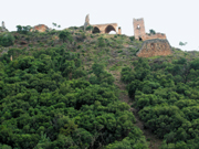
At
first, the blue trail runs beside Nahal Bartot, with several little olive trees
growing among the rocks. And then, suddenly, we saw Montfort Castle, on the horn
of the mountain between Nahal Bartot and Nahal Keziv – hence Montfort’s local
Arabic name, Qala’at Qurein (Castle of the Little Horn). Without the trees that
used to loom over it, the castle looked strange and even a little poignant. But
when we got used to it, we had to confess that Montfort is now much more
impressive.
The
trail continues to wind along the periphery of the ridge, to a bend in Nahal
Keziv between Mount Ziv and the Nakar Horn. The landscape is a combination of a
deep valley and rocky, wooded slopes. In the first two weeks of May, there’s a
bonus at the bend: the blooming of Madonna lilies (Lilium candidum, or shoshan
tzahur – white lily – in Hebrew). After that, the lilies are replaced by the
tall stalks of the rough-leaved michauxia (Michauxia campanuloides, or mishoya
pa’amonit in Hebrew), which have strange-looking white flowers.
Nahal Keziv
The
Keren Bartot trail returns to the black trail, which descends to Nahal Keziv.
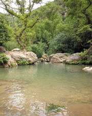
The black trail then leads down the riverbed, but we made a quick detour to the
spring of Ein Tamir, located about 300 meters up the riverbed (to the east). On
the way, we encountered a tempting pool that is a nice place to take a little
dip.
The
spring flows out of a split rock in a clear stream that runs through an expanse
of gleaming limestone. Unfortunately, the smooth surface has become a magnet for
graffiti. The plastic bags, forgotten socks, and leftover food strewn around the
area are equally infuriating.
We fled
to a prettier part of the riverbed, where we found some pools shaded by plane
trees. But then, at the junction of the trail leading to Moshav Goren, we
discovered that the large trash bins placed there with good intentions by the
INPA have become a focus of filth. From here on, the trail becomes a wide dirt
road, accompanied by numerous Syrian maple trees. This segment of the riverbed
is dry in summer up to Ein Matzor, a spring whose water emerges below the ruins
of a two-storey stone building and dam on the southern bank, at the foot of
Montfort Castle. The building and the dam date back to the Crusader period.
Archaeologists who explored the site determined that the dam created a lake
whose water was used for irrigation. The building initially served as a flour
mill, but a more elegant upper floor was later added, and apparently the
building was then used to house pilgrims and guests.
Montfort Castle
We
followed the red trail up to the castle. Montfort Castle, which rises 180 meters
above Nahal Keziv, has always been considered a jewel in the landscape. A
Crusader castle surrounded by a dense wood amid the cliffs of Nahal Keziv can’t
help but be a winning combination.
Excavations conducted at the site in 1926 by a team from New York’s Metropolitan
Museum of Art uncovered the remains of buildings, coins, and other objects from
the Roman and Byzantine periods. Some of the stones of the donjon, the massive
inner tower that is the castle’s largest and tallest structure, may have been
part of the Roman citadel that stood here. The stones of the castle were hewn in
Horvat Nahat, about 200 meters up the trail ascending from the castle.
In the
twelfth century, there was a much smaller castle in this area, meant to defend
the estates of the local feudal lords; its remains lie in what is today Mi’ilya.
In 1220, Hermann von Salza, head of the Teutonic knights, purchased a large
tract of land in the Western Galilee, encompassing Montfort. The knights called
the place Starkenburg (Strong Mountain), a German translation of the French
Crusader name Montfort.
In
1226, the knights began building one of the most beautiful Crusader castles in
the Land of Israel. It is not clear why they built it in this location, which
lacked any special strategic value. It may have been meant as a defense against
the local residents, who were not particularly fond of the Teutonic knights.
Pope
Gregory IX, calling for donations for the citadel’s construction, said, “It is
located on the border of the idolaters and therefore its construction will bring
much benefit to Christians in those areas, since it restrains the Saracens and
gives believers safe freedom from the usual troubles.” The pope promised donors
partial release from religious penalties that had been imposed upon them for
their trespasses.
The
Teutonic knights may also have chosen this location to keep their command
headquarters far away from the eyes of the other knightly orders, which were
mostly French and were suspicious of the Germans.
In
1266, at the beginning of Mameluke sultan Baybars’s drive to conquer the
Galilee, one of his commanders tried to take Montfort and failed. Five years
later, the sultan himself stood opposite the castle walls. The siege began on
June 8, 1271, and the outer fortifications were conquered three days later. The
sultan promised a large sum for each stone plucked out of the wall.
The
fighting was fierce. Eventually, the castle’s defenders laid down their arms,
after it was agreed that they would leave as free men but without their
possessions and weapons. They moved to Acre, managing to take with them the
castle’s archive and treasures, which were subsequently transferred to Venice
and then to the Teutonic fortress in Marienburg, Poland (they remain there to
this day.) Montfort Castle was never inhabited again.
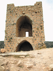
Now
that the trees have been removed, the castle is visible even from a distance and
it is easy to distinguish the three lines of fortifications. The internal wall
has been exposed, including its gate tower and opening for pouring boiling
liquids on invaders. The ceremonial hall is also very impressive. The large
cisterns and clay pipes that collected water from the roofs of the castle can
now be seen as well.
Conclusion of the Route
Still
on the red trail, we walked through the castle and made our way up via the outer
wall on the northern side. Several courses of the wall’s huge stones are still
in place. The trail passes through the moat, which borders the castle on the
east. Some 50 meters further on, it passes through a rock crevice, about a meter
wide, with steep, 8-meter-high walls. The crevice appears to have been widened
for use as an external moat.
At exactly 6 p.m., the
jackals burst into a symphony that echoed throughout the Western Galilee. While
we were walking up the trail to get to the car, we glanced back at the
landscapes of the Sulam Ridge, which forms Israel’s northern border, the Galilee
coastal plain, and the sea – a wonderful backdrop for a castle.
|