|
The trail, with red markings,
begins in the parking area and leads to one of the tributaries of Nahal Peres.
This point offers a view of the clean white desert, with acacia trees growing in
the riverbed. On the other side of the riverbed rises Mt. Zurim, 78 meters above
sea level. The mountain’s table-like shape is typical of many mountains in the
Negev due to the layer of hard rock that covers the soft chalk of the mountain,
preventing erosion.
The black-marked trail that
begins here descends into the riverbed’s eastern tributary, bypassing the pools.
Continue along the red trail, leading past the black trail and a dirt road
marked in blue. The trail climbs a bit and arrives at Nahal Peres, reaching the
top of the gorge in which the pools are located.
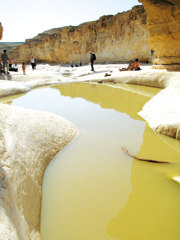
The winter rains make this
point the highlight of the hike. In the center of a 100-meter-long rocky area is
a string of pools that fill with water in the winter. It is framed on both sides
by 8-meter-high banks. A 10-meter-high waterfall adds a final touch to the charm
of this site. This is a great place for a long break. The high banks provide
shade and the area radiates tranquility.
Continue along the green-marked
trail, bypassing the waterfall from the left, to the point where it meets the
black-marked trail Follow the black-marked trail into the riverbed. The trail
now leads through a narrow gorge for about half a kilometer, passing many small
pools.
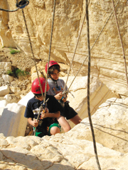
Some 80 meters before a large
waterfall, 50 meters above the riverbed, the black-marked path leaves the
channel, veering to the right, up a ladder of metal rungs attached to the rock.
Climb the ladder to the green-marked trail leading to the top of the Peres
Ascent.
You are now standing on the
remains of an ancient road that led from the Tamar Fortress to the oasis of
Zo’ar. The view of the Dead Sea and the mountains of Moab and Edom is
spectacular. From here, the trail descends to the parking area beside the Arava
Junction, where the hike ends. |