|
Midway
along the road leading up from Banyas to Majdal e-Shams, beside the grave of
Nebi Hazori, is a grove of large kermes oak trees with unusual shapes. One tree,
for example, has a hollow trunk, which someone has gone to the trouble of
bolstering with stones. Another has a bowed trunk, but still affords a great
deal of shade. But most important, between the trees you can see Mt. Hermon, its
slopes covered with a dense grove of kermes oaks that is the “ancestral
homeland” of the trees of Nebi Hazori.
Some
botanists say that in their natural form, kermes oaks are only shrubs. Others
maintain that in the right conditions, they would grow and flourish like the
oaks of Nebi Hazori – which have certainly been given special treatment, due to
the site’s holiness for the local Druze population.
Sheikh
Othman el-Hazori was a Druze holy man who was known as an ardent seeker of
peace. Legend has it that he would present people passing through the area with
a special kind of salt: it tasted good to peace lovers, but made warmongers so
confused that they forgot their target.
The
Jewish National Fund has installed a pleasant picnic site in the shade of the
grove. Don’t be alarmed at the fence surrounding the site: all you have to do is
open the green gate and go in. If you prefer, you can stop at the little picnic
site a bit further along, on the dirt road that is marked in red. This is a
newly marked trail, which will appear in the next edition of the Golan and
Hermon Trail Map, Dany Gaspar, coordinator of the Israel Trails Committee,
promises us. When we visited, we were happy to be among the inaugurators of the
trail, which leads to Nimrod’s Fortress.
Narrow
paths branch off from the red trail and take you to secluded little corners
where visitors can commune with the memory of the fallen of Sayeret Egoz, an
Israeli Special Forces unit. It’s a monument that is striking in its simplicity:
in the shade of the limestone rocks characteristic of Mt. Hermon, small basalt
stones bear the names of the fallen.
The
dirt road leads up to a large plaza beside a grove of olive trees with
impressive trunks. One trunk looks as twisted as a floor mop that has just been
squeezed out. You can already see the eastern part of Nimrod’s Fortress across
the way.
The
trail leads through the grove, exiting beside another grove of ancient olive
trees, growing among the wild trees. At the edge of the olive grove, the red
trail meets up with the blue trail, which ascends from the depths of the
riverbed of Nahal Hazor. Now you are opposite the fence of the fortress. Follow
the sign with the arrow pointing left and you will soon reach the road, and the
gate of Nimrod’s Fortress National Park. Take one of the leaflets at the gate.
Nimrod’s Fortress
Nimrod’s Fortress was built by Almalek Alaziz Othman, the Ayyubid governor of
Banyas, in 1228. Later, when Baybars became the Mameluke sultan, he presented
Nimrod’s Fortress as a gift to Bilik, his loyal friend and second-in-command.
Historical sources relate that Bilik built several towers, a mosque, and a
palace in the fortress. After his death, his son arranged for Bilik to be
murdered, apparently because he feared his power.
Construction work in the fortress then ceased. Not only was it no longer needed,
since the fortress was large and strong enough, but its strategic value declined
after the Crusaders were expelled from the Holy Land in 1291. After the Ottoman
Turks conquered the land in 1517, they used the fortress as a luxury prison for
Ottoman nobles who had been exiled to Palestine. The fortress was abandoned
later in the sixteenth century.
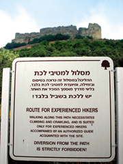
The
right way to visit Nimrod’s Fortress is not to continue on the road, as the
vehicles do. Instead, immediately after going through the gate, cross the little
olive grove that is on the right and you’ll come to a sign warning that this
route should be attempted only by experienced hikers accompanied by an
authorized guide acquainted with the site. If you’re used to hiking, don’t be
intimidated by the sign – you’ll manage without any difficulty.
Continue on the trail, which is well marked with stones along the side, and make
your way up the steep slope, on a stepped path with a clear route, until you are
at the foot of the eastern tower of the fortress. In the northern part of the
tower, you’ll see a small opening, which you can get through by crawling.
Beyond
the opening is a passageway built of large, well-chiseled stones, which leads
straight to the donjon (a massive inner tower), which is also the highest part
of the site. The view is splendid: from here you can easily see the slopes of
Mt. Hermon, the northern Golan, and the Hula Valley.
A
proper stroll through the fortress takes about an hour and should end up on the
western side, where you’ll find a snack bar, rest rooms, and several tables
under a thatched roof – an appropriate place for a break.
To the Sources of Nahal
Hermon
At the
edge of the parking lot, set out on the trail marked in green. The route was
marked only recently and it helps you to negotiate the rocks.
Climb
up the low ledge and then continue down the green trail to the Banyas Spring.
The trail descends on the watershed line of a gentle slope, where you’ll find a
sparse olive grove, which is accompanied by a large number of spiny broom
bushes.
The
view is magnificent. The mountains of southern Lebanon, the Hula Valley, and the
Naphtali Mountains are with you all along the way. A green line of plane trees
meanders through the valley, marking the route of Nahal Hermon.
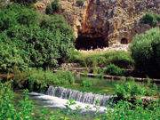
The
trail leads directly to the observation terrace offering a lovely view of the
Banyas Spring from atop the cliff, over the temple to Pan. The gleaming white
building beside the grave of Nebi Hadar is on the slope to the right, and the
old mosque is clearly visible on the left, beside the ruins of the Crusader
fortress.
From
the observation terrace, the trail leads down through a forest of Mt. Tabor oaks
and reaches the fence of the nature reserve. Walk to the left, along the fence,
until you reach an abandoned house. Beside it is a little opening in the gate.
You can enter, but first pay at the ticket booth and take the leaflet describing
the routes in the reserve. (Members of the Matmon club of the Israel Nature and
Parks Authority are admitted free of charge.)
All of
the information you need is in the leaflet. Just make sure your first stop is
the ruins of the temple to Pan, where the Israel Nature and Parks Authority has
carried out impressive reconstruction work. Then continuealong the riverbed.
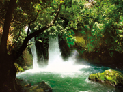
To the Banyas Waterfall
From
here on, the route is replete with water – the water that flows through Nahal
Hermon. Head for the Banyas Waterfall. The trail crosses over to the right bank
via a wooden viaduct, and then goes back across to the left bank. This passage
runs under the arches of a Roman bridge. Note the true laurel tree in the
western part of the bridge.
After
passing the abandoned hydroelectric station, you’ll come to a nicely
reconstructed flour mill. You can take a break here and enjoy thin Druze pita
baked on the spot.
Before
setting out for the trail to the Banyas Waterfall, make a detour to the left to
the site of the Roman-period city of Banyas, large portions of which were
exposed in archaeological excavations. Allow for a visit of about an hour.
Follow
the trail to the waterfall along the left bank of the riverbed. You’ll come to
an observation terrace offering a view of the most impressive waterfall in
Israel. You can replenish your own water supply at the tap beside the
observation point.
After
you have enjoyed the view of the waterfall from above, go down to it by crossing
over to the right bank of the riverbed. You’ll come to a junction of trails,
with the trail on the right leading to the waterfall, a two-minute walk. The
trail to the left, with black markings, leads to Moshav She’ar Yashuv.
Down Nahal Hermon
Once
you’ve been refreshed by the spray of the waterfall, continue down the riverbed
in the direction of She’ar Yashuv. Don’t be alarmed when you come upon a locked
gate: just ask the the reserve ranger standing beside it to open it for you.
This
trail may be the only one in Israel that features a walk of several kilometers
along a flowing riverbed. After crossing a basalt barrier, the riverbed enters a
black canyon about 3 meters wide, and the stream turns into a rushing river. You
get to view it from above, on the high ramp you’re walking on.
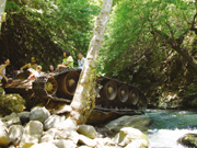
At the
end of the narrow canyon, follow the trail leading down to the channel of the
riverbed. It will take you to a beautiful, shady spot beside the riverbed, where
you’ll find an overturned Syrian tank, with water lapping at it. During the Six
Day War, five Syrian tanks tried to attack Kibbutz Dan, about 2 kilometers to
the west, but were fended off. This tank was apparently beating such a hasty
retreat that it ended up falling into the channel. Its belly makes a good dining
surface, but please don’t leave any leftovers behind.
Go back
up along the trail and continue to walk on the high bank of the riverbed. When
you come to a lovely cluster of large Mt. Tabor oaks, look at the opposite
slope, on the eastern bank. Usually, you can see the waterfall of Nahal Pera,
which descends from the ruins of the village of Ein Fit and splashes into Nahal
Hermon in a series of three steps with a total height of some 70 meters. In
especially rainy years, such as this one, a nice amount of water flows through
the riverbed even in August.
The
trail continues on the western side of Nahal Hermon, high above the channel.
After about 300 meters, it passes beneath large jujube trees. Above the trees,
on the slope of the riverbed, is a travertine step hewn with burial niches from
the Roman period.
Continue down the riverbed; large plane trees grow alongside it here. Cross over
to the left bank and you’ll see a dirt road (suitable for jeeps) that climbs
left on the step above the channel. Rather than trekking along the dusty road,
take a new trail marked in red that branches off to the right. It continues
alongside the riverbed, between fig, willow, and plane trees, and sometimes
through a “tunnel” of reeds.
When
you see the three gigantic Mt. Tabor oaks to the left of the trail, you’ll know
that you’re nearly at the end of the route. This used to be the site of the tomb
of Sheikh Mahafi, near a small spring that flows in a narrow rivulet to Nahal
Hermon. Take a moment to enjoy the shade of the trees and marvel at their size.
Now all that remains to
be done is to continue a bit further, meet up with the dirt road, and follow it
to the bridge that leads to She’ar Yashuv, the ending point of the hike.
|