|
|
|
ISRAEL
TRAIL - SOUTHERN FINALE
This
strenuous hike takes you from the Shehoret Canyon in the Eilat Mountains, along
the last 25 kilometers of the Israel Trail, to the Taba Mountains
|
The sun had already risen, but its rays had not yet penetrated the campsite beside the canyon of the riverbed of Nahal Shehoret, the starting point for our long hike. The walk up the riverbed along the Israel Trail was a pleasant way to begin. The canyon was lovely, with dark, beautiful rocks. Even the dry waterfall (approximately 4 meters high), where the winding channel narrows to a width of only 2 meters, wasn't a particularly big challenge. All we needed was a gentle push from the people behind us and everything was fine.
. |
|
A
Little Lesson in Geology |
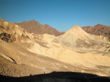
It all changed when we got to the point where the riverbed meets the northern slope of Mt. Shehoret (586 meters above sea level). A steep, high wall rose before us. Mt. Shehoret is a large slanted mass, surrounded by a fault line. Still, it is also the brightest place in the area, since the mountain consists mainly of limestone. The mountain was given its name, which derives from the Hebrew word shahor (black), because of the dark riverbed by the same name at its foot.
The Israel Trail climbs southward (left) to a lower saddle, where limestone meets granite. This means that nearly every step bounces the hiker back and forth between hundreds of millions of years. The top of the saddle affords a nice view of the area, including the mass of colorful sandstone of Mt. Amir in the north and Mt. Shlomo in the south.
Beyond the saddle, we could already see the multicolored sandstone. In Nahal Shehoret we had walked through bedrock - rock that slowly solidified from liquid magma in the depths of the earth's crust. This bedrock marks the northern edge of the Arabo-Nubian Massif, which formed more than 550 million years ago.
The sandstone, on the other hand, formed much later, in the Lower Cretaceous period (141 to 100 million years ago), when the area consisted of dry land. It stratified on the massif after it was carried by rivers that drained from Sinai, Jordan, Saudi Arabia, and perhaps even extensive parts of Africa. The colors of the sandstone come from various oxides, whose origin is not completely clear. It seems that at least some of them arrived via the underground water.
At the end of the Lower Cretaceous period, for about 70 million years, a sea flooded the area and the limestone formed in it, stratified onto the sandstone. Dramatic geological activity is still taking place in this area. Entire layers have been destroyed by erosion and others have been shifted by deep faults.
|
|
"Lost
Gorge" |
We made our way down the trail through the colored sandstone to the large valley formed by Nahal Roded. A very short black-marked trail makes a detour to the east (right) and enters a very short hidden crevice, which has acquired the picturesque name of "Lost Gorge." Blocks of sandstone in the crevice rise to a height of more than 20 meters, resembling the famous Solomon's Pillars. Some call them "the Roded Pillars."
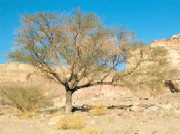
The broad valley of Nahal Roded was formed by the fact that the riverbed dug its way through a large geological fault line. It collects enough water to sustain the large "Negev acacias" (Acacia gerrardii in Latin, shitat hanegev in Hebrew) that grow in it. A few of these trees have unfortunately dried out and died, apparently because the acacia strap flower, a parasitical plant with reddish flowers hanging from the trees, saps their water and minerals.
On the edge of the valley, on a slope descending from Mt. Yehoahaz, a large group of rock piles can be seen, with a blue-marked trail leading to them. This is an isolated ruin (Horvat Roded) - a site containing a group of small structures situated in artificial depressions. Archaeologist Dr. Ze'ev Meshel thinks the site was used as a quarry in the Byzantine period and not as a real settlement, and the quarriers used the hewn sections to build small rooms for their living quarters.
The only problem with this theory is that there are no Byzantine buildings nearby, so it is not clear where the quarriers took the hewn stones. It may be that they found this site to be a good source of stone for building roofs, which they hauled to the Byzantine town of Ayla (Eilat) to cover the houses there.
|
|
Nahal
Netafim |
We reached the watershed line, with the drainage basin of Nahal Netafim beyond it. Here, too, the lovely, narrow channel, flanked by upright walls 10 meters high, navigates the line between sandstone and granite, with its hue changing back and forth between pink and dark shades.
When the Israel Trail (with green marking) meets the channel of Nahal Netafim, it turns right, up the riverbed. Here we had two options, and we took advantage of both of them.
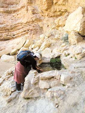
First, we continued walking in the channel and passed through a canyon that is about 700 meters long and features a series of little dry waterfalls; colorful intrusions in the walls of the canyon add to the fun. Then we went back to the Israel Trail, which circumvents the canyon from the right and reaches Ein Netafim - a tiny spring whose water drips and flows through little grooves into a man-made trough at the rate of 15 liters per hour. Eventually, the water fills the trough, which is about 2 meters long and about 1 meter wide. Southern maidenhair ferns contribute a fresh green hue to the spring, which is an important source of water for the local wildlife.
After spending a little time at the spring, we climbed the ladder of handles implanted in the rock crevice and then walked up the dirt road to the western border highway (Road No. 12). Here we turned left, toward Mt. Yoash (734 meters above sea level), which rises beside the road. Before the mountain, we followed the Israel Trail as it made a right turn on a narrow ridge separating Nahal Yoash and Nahal Gishron.
|
|
Nahal
Gishron |
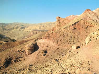
Crossing the border highway instantly took us into other landscapes. We immediately got a look at the sandstone cliffs of Nahal Yoash, one of the rivulets of Nahal Shlomo. A little bit further and...boom! We saw the wild landscapes of Nahal Gishron, a deep crevice between steep, dark mountains, descending from the Eilat Mountains toward Sinai. Nearly opposite, beyond the riverbed, border stone No. 87 can easily be seen.
The trail passes the large blocks of sandstone strewn around the slope of Nahal Gishron. Here we had to circumvent the canyon of the upper part of the riverbed. The trail runs through a narrow, steep groove, and the rope attached to the wall definitely helped. Just below the rope, we came upon the beautiful golden spiny mouse and an Agama sinaita, known popularly as the blue Sinai lizard, sunning itself on the rock.
The groove widens to a narrow, pretty channel and leads to a dry waterfall, implanted with two 8-meter-high ladders - a rope ladder and an iron ladder. A bit further down the riverbed is a hand ladder. After taking advantage of these aids, we continued along the trail to the foot of a reddish granite dry waterfall, 25 meters high, in the main channel of Nahal Gishron.
Further on, the riverbed digs its way through spectacular colored sandstone. As soon as we came to this rock, we saw on the left (north) blurred ancient rock carvings, depicting ibexes and groups of camel riders - perhaps a hunting scene.
Some 30 meters before the sign stating "Tzafra Pass," also to the left, we came upon additional rock carvings. The carvings are on steep walls that are in the shade for many hours each day, and it may be that the pictures were carved by bored shepherds or people who were taking shelter in the heat of the day. "Tzafra Pass," by the way, is named after a plump hiker who got stuck in the narrow crevice leading to Nahal Shlomo many years ago.
The channel of Nahal Gishron becomes narrower on its way down, creating little dry waterfalls, which are easily navigable until the Gishron Ascent, which climbs steeply up the left (northern) bank of the riverbed. Don't continue down the riverbed - it leads into Egyptian territory.
The ascent ends at a very narrow ridge on whose other side is a white conical hill, completely different in character from the surrounding mountains. This is Rehavam Hill, situated in the heart of a syncline, in which sedimentary rocks settled in the Eocene epoch, when the ancient Tethys Ocean flooded the region and reached this point.
Most of the syncline is covered with soft chalk, but at the top of Rehavam Hill there is still hard limestone, which has managed to preserve the soft slopes below it.
A good vehicular road leads to the ridge from Nahal Shlomo, so hikers can arrange to be picked up at this point if they wish to stop here.
We stayed on the trail, which reached a large, impressive wall of smooth stone and continued atop the wall. The "red" trail changed its color to black, seemingly for no reason. But there was one, which had to do with the history of the trails in the area.
In the past, the "red" trail led up from Tmilat Taba (tmilat is an Arabic word referring to a spot where water is buried under the surface of a dry riverbed) on an ascent that passed large limestone bulblike masses strewn on the ground. Since Tmilat Taba is situated in Sinai, people hiking the Israel Trail can only enjoy the bulblike masses at the top of the ascent, which is the meeting point of the "red" and "black" trails.
|
|
Smashing Conclusion |
From the top of the ascent, we reached the top of Mt. Zefahot, which is only 278 meters above sea level but offers a marvelous view of the Gulf of Eilat and the Mountains of Edom.
And that was only the beginning.The trail now led down toward the sea between mountains of schist (zefahot), granite, and an enormous variety of stunning metamorphic rocks. From time to time, we could also catch a glimpse of Coral Island.
The trail unites with a short dirt road and leads down to the highway, very close to the Eilat Princess Hotel. At the highway, a bit before Taba and the Israel-Egyptian border, the Israel Trail reaches its southernmost point. |
|
|
|
|
Length of Hike: 25 km Duration:
Approx. 11 hours Cut off Points: Road No. 12 beside Mt. Yoash – after 11
km; Mt. Rehavam – after 17 km; Eilat Field Study Center – 1.5 km less than the
full route.
Water: There is no water along the route, so make sure to bring your own.
Map: Eilat Mountains Trail Map (No. 20), 2004 edition, Hebrew & English.
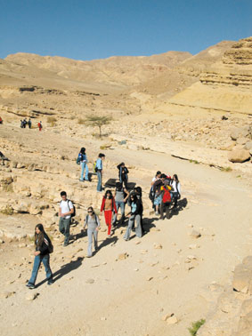
In winter,
the trails in the Eilat Mountains are full of twelfth-graders on school trips,
as well as members of youth movements. Some of the hikers unfortunately leave
graffiti and trash in the area. To help maintain the area, the Israel Nature and
Parks Authority (INPA) is planning to charge an entrance fee in the Red Canyon.
The INPA also has made an agreement with hike caterers that aluminum-foil
containers will not be used. In addition, every group comprising at least 50
participants that camps in the area is now required to be equipped with chemical
toilets.
The plastic bag problem is especially distressing. In the base occupied by the
Eilat Division of the Israel Defense Forces, twenty ibexes used to live off
leftovers they found in trash bins. They also swallowed plastic bags and other
garbage that was harmful to them. In cooperation with the division, trash bins
with lids were installed at the base and the soldiers have been ordered to keep
the bins covered.
Ibexes no longer roam the base. The number of ibexes in the Eilat Mountains is
now estimated at 80, down from 120 in previous years.
ERETZ recommends that hike
participants take part in the cleaning of the trails in the Eilat
Mountains during hikes. Groups interested in doing so should contact
the INPA, Tel. (08) 637-3988, and they will receive instructions and
plastic bags for collecting garbage.
|
|
|
|