|
More than
anything else, Tzur Hadassah Junction symbolizes the end of the
age of innocence in Israel. The natural conditions are
wonderful: mountain slopes covered with old agricultural
terraces, the aroma of good soil mingled with the scent of
pines, and clear air. Until recently, even the community of Tzur
Hadassah had a pleasantly undefined character – not a kibbutz,
moshav, village, or city, it was just a little place beside Mt.
Kitron.
Don’t
bother to try to find Mt. Kitron today. It’s now a neighborhood
of Tzur Hadassah, with private houses coated with light-colored
stone. Some 20,000 people are meant to live in Tzur Hadassah in
houses like these in the future. Soon the houses and those of
Beitar Ilit, situated on the next ridge, will be right next to
each other.
The
Jerusalem City Hall is 14 kilometers from here, as the crow
flies. Some day soon, municipal officials will start talking
about demographic problems, pull out maps and statistics, and
claim that in fact, Tzur Hadassah is an integral part of
Jerusalem.
But on a
nice spring day, what did all that have to do with us? In the
meantime, we could look in another direction from the junction
and feast our eyes on the Jerusalem Mountains.
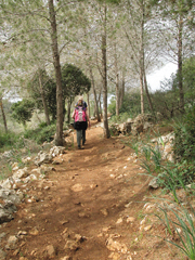
The Israel
Trail, marked with orange, blue, and white stripes, reaches this
point on its way westward. This marking would accompany us
throughout the day. We found it on the electrical poles at the
junction and turned on to the dirt road that enters a KKL-JNF
grove, beginning the first segment of our hike before reaching
the Emperor’s Road.
At first,
we were still walking parallel to the road leading to Bar Giora,
but the trail soon descended to the left, down the upper
tributaries of the riverbed of Nahal Zanoah, and passed beneath
a massive high-tension line. Known as Line 400, it belongs to
the days when people were talking about a New Middle East, and
the electricity flowing through it was meant to flow through
Egypt and Jordan as well.
At the top
of the slope to the right, we could see the beautiful terraces
of the abandoned
village of
Ilar al-Foka and a makam (a shrine to a Muslim holy man) with a
white dome.
Zev Vilnay,
in his guidebook to the Land of Israel, called the makam Sheikh
Ahmed el-Hubani; nineteenth-century traveler Victor Guerin
referred to the site as Sheikh Hubin.
We
continued down the road without going up to the makam. When our
path met a paved road leading from Moshav Matta, we turned right
toward a large terrace and went up to the antiquities site known
as Horvat Darban. The walk among the terraces, covered with
little shrubs of wild marjoram and other undergrowth, was a
refreshing change. In winter, some of the trail markings
disappear under the high grass, but it is easy to keep sight of
the ancient stone wall that stands atop Horvat Darban and
encloses an area containing almond trees.
Horvat
Darban acquired its name when a porcupine (darban in Hebrew),
digging itself a burrow in the southern slope of the ruins,
exposed a potsherd bearing an imprint stating “for the king.” It
dated from the time of King Hezekiah (705-701 BCE).
Archaeologist Yohanan Aharoni subsequently dug at the site and
found pottery from the Persian period (538-332 BCE).
We wandered
around, came upon caves hewn in the rock, and gazed at the
stunning landscape: Horvat Beit Itab, to the north, looks like a
remnant of
a fortified building; the moshavim Bar Giora and Ness Harim
occupy the adjacent peaks; and below lie the houses of Moshav
Matta.
The trail
passes the walled area in Horvat Darban, meets up with a
blue-marked trail, and descends westward toward Matta. We could
discern eucalyptus trees beyond the moshav, pointing to the site
of the spring of Ein Matta.
Until the
trail reaches the spring, it runs past hewn openings in the
rock, prickly pear hedges, and terraces laden with fruit trees.
Blue lupins sprout here in abundance in January and bloom with
lovely flowers in March. Numerous cyclamens grow on the last
terrace, beside the road that runs along the periphery of the
moshav.
After
passing a palm tree nursery, we immediately reached the little
eucalyptus grove. A small brook flows nearby, and on its eastern
side is a small man-made pond, with stalks of narrow-leaved
reedmace growing in it.
The spring
itself is situated a bit further up the channel. Horvat Tanor,
beside the spring, contains such ruins as a large stone house
with arched windows and walls that have survived to a height of
about 7 meters. Estimated to date to the Crusader period, it is
thought to have served as a farmhouse or perhaps a monastery.
Between the
house and the spring is another little spring, Ein Tanor. Local
legend has it that this was the site of Noah’s stove (tanor in
Hebrew). The stove, it is said, was submerged in the Flood.
After the waters receded, the stove, tired of heating food,
decided to produce water instead, which it does to this day.
Guerin described this site as having orchards with trees so
luxuriant that no ray of light could pass through their leaves.
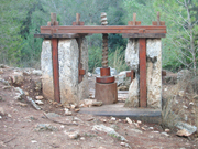
The Israel
Trail makes its way up the southern slope of Nahal Zanoah to
Horvat Hanot (Khirbet el-Khan), situated in the shade of a
forest where KKL-JNF has created a pleasant picnic site. The
road beside Horvat Hanot leads up from the Ela Valley to Bar
Giora (Road No. 375), along the route of an ancient
thoroughfare. The ruins of a khan, or caravansary, in Horvat
Hanot, attest to the old road’s existence. Its walls survive, as
well as a floor covered with sand that conceals a colorful
mosaic from the Byzantine period; the sand protected it from
vandals over the ages. An ancient wine press beside the khan has
a simpler, white mosaic floor.
A large
sign states that this is the beginning of the Emperor’s Road,
which is clearly delineated not only with the markings of the
Israel Trail, but also with the local trail markings
(white-red-white). KKL-JNF has marked the trail with large rocks
along the periphery.
We followed
the trail through a lovely Mediterranean wood mixed with a
sparse forest of pines, and soon reached hewn steps.
Archaeologists suggest that these steps were part of a Roman
road from Ashkelon to Jerusalem, built in 130 CE in honor of the
visit of Emperor Hadrian – hence the name “Emperor’s Road,”
given to it by a KKL-JNF employee.
The trail
is narrow, pleasant, and meant for pedestrians, but those
walking along it on a Saturday are liable to come upon cyclists
looking for challenges. “Cyclists in Israel like to ride on the
footpaths, which they call ‘singles,’ because the paths have
room for only one bicycle,” explains Dani Gaspar, coordinator of
the Israel Trails Committee. “There have already been several
accidents. The Israel Nature and Parks Authority has instituted
a regulation prohibiting cycling on footpaths in national parks
and nature reserves. We’re now mapping out a national bicycle
path and we hope it will at least be a solution for the Israel
Trail.”
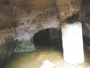
We walked
down to Nahal Hanativ, and when we reached the road that runs
through the channel, we saw a square underground cistern. Shaped
similarly to Nabatean cisterns in the Negev, it is apparently
from the Roman period. A round column supports its natural rock
ceiling, and the original plaster remains in a few walls.
We crossed
the riverbed via a small wooden bridge, and then passed five
fragments of large, round columns, which probably served as
milestones on the ancient road. We also passed a reconstruction
of part of an old olive press, after which we descended to a
large plaza beside the Tzur Hadassah-Ela Valley Road, where we
concluded the hike.† n
|