|
For the
hikers among us, the phrase “Judean Desert” evokes images of deep canyons, steep
ascents, and springs at the foot of Ha’etekim Cliff, which rises above the Dead
Sea. Some people speed along its thoroughfares in jeeps, but only a few cross
the desert on foot from west to east. In just one day, a good hiker setting out
from Arad can cross the desert, even diagonally, and reach Masada.
The optimal time to do this is
between October and March.
Nahal
Tabiya
We
began at the riverbed of Nahal Tabiya, which descends southward from the center
of Arad (see “Useful Information” for directions to the starting point). After
passing several benches and planted ornamental trees, we suddenly lost sight of
any sign of civilization and found ourselves walking down the Judean Desert
channel.
Like
seven other trails around Arad, Nahal Tabiya was recently given trail markings
(in its case, blue). Arad resident Dov Punio, who joined us on our walk in the
riverbed, said: “The marking of the trails was the idea of a group of hikers who
live in Arad. We met with Dani Gaspar, coordinator of the Israel Trails
Committee, and to my surprise, Dani immediately said, ‘No problem. Put a
temporary marking on the trails and we’ll get the appropriate approvals to mark
them with paint and put them on the trail map.’ Three months later, all 32
kilometers were permanently marked during a three-day period.”
We
continued walking and came upon a group of children in the riverbed. They were
from the environmental protection club of the Kedem Democratic School in Arad.
“We go down to the wadi and study everything that there is here,” said teacher
Eitan Shaked, who leads the group. “We also have nature protection activities
and are always cleaning the wadi. We hauled away a tremendous amount of garbage
and very heavy debris and we report every leak from Arad’s waste-treatment
plant.”
A green
stripe of broad clotbur (Xanthium strumarium, or lachid hanehalim in Hebrew), a
plant that grows in habitats in which there are seasonal water pools, attested
that the leaks are a routine matter here. Suddenly, in the middle of the
riverbed, we saw a supermarket shopping cart. “These carts are stolen in large
quantities, especially around Lag B’Omer [to carry wood for bonfires],” Shaked
said. “We send them back up to Arad. We took one cart out of the wadi four
times.”
Further
on, the riverbed is a pretty and apparently protected place. The young
environmental activists took us to a shady spot that is such a favorite of
theirs that they call it “our home.” To everyone’s amazement, a real house had
sprung up there. A local Bedouin had blocked part of a little cave with a wall
of bricks, built cement steps, and added shelves and a lamp. The kids vowed to
check into the matter.
Nahal
Tabiya continues to wind its way several times between the hard, cracked
limestone couches of the Kidud Ridge. Large bushes of white broom grow in the
rock crevices, and in early winter, Day’s marjoram (Origanum dayi, or azuvit
hamidbar in Hebrew) blooms here, with aromatic leaves that make a nice addition
to a cup of tea.
Nahal Ye’elim
In the
spot where Nahal Tabiya meets a little channel that comes from the left, just
before it reaches Nahal Ye’elim (Riverbed of the Ibexes), grows a wonderful
umbrella acacia (Acacia tortilis, or shita sochachanit). This is an ideal place
to have breakfast. The large, beautiful tree can provide shade for a large group
of hikers.
In
Nahal Ye’elim, we no longer saw the layers of hard limestone of the Kidud
anticline. This meant that we had moved on to the area of the large syncline of
the Judean Desert, which was covered mainly in the Cenozoic era (88-65 million
years ago) with sediments of bright, soft chalk. The inhabitants of this area
during the Byzantine period realized that soft chalk is impermeable to water and
made good use of this knowledge. After walking 200 meters, we saw to our left,
behind a low wall made of rocks at the bottom of a light-colored rock cliff, an
opening leading to a large water hole: the Kidud ma’agora (WHAT IS THE WORD IN
ENGLISH?).
A
ma’agora is a special kind of reservoir hewn in the side of the riverbed,
slightly above the level of the channel. It is a large chamber, whose ceiling is
the natural rock; if necessary, the hewers of the reservoir left rock columns in
it to support the ceiling. The ma’agora collects floodwater from a higher point
in the riverbed by means of a diversion canal.
The
Kidud ma’agora is very large – about 14 meters long. A great deal of silt covers
its floor, but judging from other ma’agorot, it is about 5 meters deep. As a
rough estimate, its volume is more than 350 cubic meters. From the opening, we
could see the edge of the deep diversion canal.
We
continued walking down Nahal Ye’elim for about another 200 meters and
encountered a trail marked in red on the right. We turned onto the red trail,
which continued along Nahal Ye’elim, but after walking about one kilometer, we
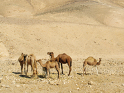
began to feel that something wasn’t quite right. We saw camels and donkeys
roaming around, a tent, a little shack, and suddenly we found ourselves in a
Bedouin settlement built of tin huts.
We
passed among the tin huts and were greeted only with silence and intense
scrutiny. We later learned there is an ongoing struggle over land in this area
between the members of the tribe and the Israeli authorities. Judging from what
we saw, the two-kilometer-long settlement penetrates several hundred meters into
the Judean Desert Nature Reserve. In any event, the entire settlement was built
illegally.
We
continued to trudge through the wide channel of Nahal Ye’elim. This riverbed
passes along the seam between the Tahrorim rock formation and the chalk plateau
north of it. Tahrorim is a unique formation, which contains a variety of rocks
in an assortment of color configurations – brown and green, pink and yellow,
green and purple and black, and others. It is not completely clear how the
formation came about. The leading theory is that it is made of rocks that
underwent a metamorphosis – perhaps caused by absorbing hot water. The formation
is situated beside bituminous rock, whose organic compounds, including
petroleum, might be connected to some kind of conflagration that “baked” the
rock of the Tahrorim formation.
Bulbs and a Jujube Tree
When
Nahal Ye’elim makes a wide turn to the right, the trail cuts across the bend and
climbs up a low ridge in order to shorten the way. From here, it crosses Nahal
Ye’elim from south to north in order to ascend a nakab in the wall of hills that
enclosed us from the north. Nakab is an Arabic term for a natural passage in a
mountainous area that is wide enough for a camel to pass through. The word is
very similar to the ancient Hebrew word nakubta.
This is
where we really began to have fun. We were surrounded by a clean and beautiful
desert. We followed the nakab along the periphery of the Kena’im anticline, made
of hard limestone and dolomite. At the highest part, on the right side, clusters
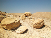
of flint stones marked an ancient Bedouin cemetery. After walking 100 meters, we
were greeted by huge bulblike masses of rock more than a meter in diameter, some
of them standing(OK?) at very interesting angles.
Before
the nakab began to descend, we stopped and looked at the landscape. To the east
is the Dead Sea with the wall of the Mountains of Moab behind it. To the north
is the continuation of the Kena’im anticline. The narrow canyons of Nahal Kidud
and Nahal Menahem burst out of the anticline and unite at its foot into a broad
valley, which links up with Nahal Rahaf. The edge of Nahal Rahaf’s wonderful
canyon, which cuts through He’etekim Cliff above the Dead Sea, can be seen
easily as well.
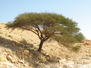
At the
foot of the nakab grows a lovely jujube tree, its fresh green hue a striking
contrast to the white rocks around it. It has five large, high branches,
providing shade that is a dream come true for every desert hiker.
The Yonatan Bypass Trail to
Masada
We
reluctantly left the jujube tree and set off to cross the beautiful valley at
the foot of the Kena’im anticline. We circumvented Mt. Yonatan from the south.
The chalky Mt. Yonatan is typical of the residual hills in the Judean Desert.
The rocks around it eroded and it was left alone, perhaps because it is attached
to the Kena’im anticline, which protected it.
We
descended to Nahal Emunim, where we saw a large umbrella acacia growing about 70
meters to the right of the trail.
The
trail crosses a dirt road for 4x4 vehicles, marked in green, which links the
western part of Masada with the Arad-Dead Sea Highway. Now we had to climb the
saddle?? at the foot of Mt. Elazar. We usually wouldn’t complain, but we had
already walked 20 kilometers and so we permitted ourselves to take our time
climbing up. A bit before the ascent, our red trail joined up with a trail
marked in black.
The end
of the ascent is a lookout point with a spectacular view of Masada. We really
wanted to go up to Mt. Elazar along the ramp the Romans built during their siege
of Masada and look at the mountain from the camp of the Eighth Roman Legion.
However, the Israel Nature and Parks Authority does not permit hikers to walk
down the steep Elazar Ascent toward the Masada Youth Hostel. The INPA considers
such a steep descent too dangerous for hikers. Therefore, we continued like good
boys on the red trail, along the Roman ramp, passing the steep cliff that
creates the gorge separating Mt. Elazar from Masada, and ending the hike on the
western side of Masada.
|