|
Early in the morning, we parked the
car above Safed’s military cemetery, taking advantage of the
fact that a concrete staircase leads straight down from there to
the city’s old cemetery.
For hundreds of years, numerous
tombstones have accumulated in the old cemetery. Some of them
are quite dilapidated, but the tombstones of well-known people
are painted either white or in eye-catching shades of blue.
Among those buried here are the famous kabbalists of Safed, the
most prominent among them being Ha’Ari, Rabbi Yitzhak Luria.
There is nearly always someone praying beside their graves,
hoping that the souls of the holy men will help the prayers
reach the right ears.
Prayer
for those who dwell in the dust
Opposite is the beautiful scenery of
the large, green Mt. Meron. Nahal Meron, which flows into Nahal
Amud, looks like a slight wrinkle in the slope of the mountain.
We could clearly see the abandoned British police station on its
southern bank. It was built in the time of the Arab uprisings of
1936-39 in order to protect the pumping station that brought
Safed the water of the spring of Ein Yakim, which emanates from
the channel of Nahal Meron. The prominent silhouette of Mt.
Mitzpe Hayamim juts out from over the western bank of the
riverbed.
We walked down the path between the
graves to the lower plaza of the cemetery, where we came upon
two fig trees whose branches were adorned with plastic bags and
pieces of cloth waving in the wind – a clear sign that this was
a sacred place. “Life exists thanks to the prayer of those who
dwell in the dust,” reads a sign at the spot, attributing the
saying to the Zohar, the mystical tractate studied by many
kabbalists. We checked as thoroughly as we could. There is no
such passage, but it is nice that someone bothered to convey to
us a bit of the spirit of Rabbi Shimon Bar Yohai, who relates
his kabbalistic vision in the Zohar.
Nahal
Sechvi
The channel of Nahal Sechvi, via
which we were to descend to Nahal Amud, was now very close, a
bit north of the cemetery (to the right). But the new highway
leading up to Safed blocked our way. We had no choice but to
turn left (south) at the lower gate of the cemetery.
Beside a faded yellow building, we
encountered the first blue marking of the trail. Here we turned
right and crossed the highway below. Afterward we made another
right turn (north) and walked parallel to the highway. We passed
a grove, which also had its share of graves of holy men. Further
on, two lovely funeral cypress trees, whose branches grow
horizontally, signaled the descent to Nahal Sechvi.
The name of this riverbed (Riverbed
of the Rooster) is based on its Arabic name, Wadi el-Jaj. The
rooster’s haunting cry is very compatible with the kabbalistic
spirit of Safed.
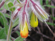
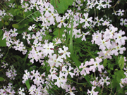
We visited in spring, a delightful
time to be in this area. Green carpets of Egyptian honesty grew
among the Atlantic pistachio trees, together with tall columns
of yellow asphodels and many other flowers. Amid all of this
opulence, we nearly didn’t notice the old paving stones that
cover a segment of the riverbed.
Near the Fulling Mills
The paving of Nahal Sechvi probably
began in the fifteenth century, when Safed became a center for
the production of high-quality woolen fabrics, which were
exported to customers all over Europe. The expertise in this
field was brought to Safed by Jews expelled from Spain and
Portugal; they had first settled in Salonika and Adrianople (Edirne),
where they learned the trade.
Rabbi David de Rossi, who visited
Safed in 1535, wrote: “Many Jews are arriving all the time and
the clothing [textile] business is growing every day… and every
man and woman who works in wool at any trade will earn a good
living.”
What do the textiles of Safed have
to do with the paving stones in Nahal Sechvi? The answer lies in
the fact that in order to turn the woven wool into felt, it has
to be beaten repeatedly, until the threads are very tight. This
process, known as fulling, shrinks the fabric to half its size.
In ancient times, a wooden club was
used, or the fabric was immersed in water and trampled on – an
arduous process. In the twelfth century, a mechanical fulling
mill, driven by water power, was invented in Europe. Spanish
Jews brought the new technology, which they called batan, to
Safed.
The mechanical fulling mill changed
the system of producing woolen fabrics. The industry moved from
tiny workshops in large cities to rural areas with an abundance
of flowing water; Safed’s citizens utilized the water of nearby
Nahal Amud. (The Arabic name of one of the structures in upper
Nahal Amud, not far from the spring of Ein Po’em, is Tahunat el-Batan,
a clear indication that at a certain stage in its life it
functioned as a fulling mill.)
Textile merchants invested in the
construction of fulling mills and it may have been they who
paved Nahal Sechvi, which offered the shortest route to the
Sechvi pools in Nahal Amud.
The End of the Textile Era
The shallow Sechvi pools, which
contain water all year round, create a charming little corner of
the riverbed. Large plane trees are reflected in the clear
water, and there are also fig trees, an abandoned flour mill,
and a cave. Few hikers can resist the urge to take a little
break here.
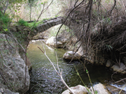
We began to walk down Nahal Amud,
following the black marking and the marking of the Israel Trail.
Thanks to this year’s rainy winter, the riverbed was host to a
rushing stream. We occasionally passed an abandoned flour mill.
It can be assumed that the structures close to Safed served at
some point as fulling mills. We also passed ancient arched
bridges, offering further evidence of the flourishing industry.
In 1576, the Ottoman authorities
ordered the exile of 1,000 Safed families to Cyprus, an act that
wiped out most of the city’s textile industry. Jews continued to
work in the industry on a small scale until the end of the
seventeenth century, and the fulling mills were subsequently
converted into flour mills.
The Middle of Nahal Amud
Further down the riverbed, we no
longer saw any mills. We were now in a purely natural setting.
Interspersed with the trees of the Mediterranean wood were
hedges of prickly pears and remains of olive and almond trees. A
riverbank forest of huge oriental plane trees accompanied us all
along the way.
After about an hour and a half of
walking, we saw a (blue) trail to our left leading up to the
spring of Ein Koves, a half-kilometer walk. The Hebrew name Ein
Koves echoes the name of Sheikh Kwayis (“the good sheikh”),
whose tomb lies on the side of the trail.
From Mt. Meron’s slopes to the Sea
of Galilee, Nahal Amud overcomes a height differential of about
1,200 meters in the course of only 25 kilometers, and so we knew
it was only a matter of time until we came to a canyon with
waterfalls. And sure enough, not far from the hidden spring of
Ein Seter, we saw a long, narrow canyon, in which water cascades
down mightily in winter.
The trail circumvents the canyon
from the right and then leads back down to the riverbed. Here
the trail shifts to the northern bank, but we continued in the
channel for another 150 meters, in order to see the lovely
curtain of water on the left side of the spring. The spring
bursts out of a crack in the rock, about 20 meters above the
channel of the riverbed.
We returned to the trail and moved
over to the eastern bank of the riverbed. We could see the water
of Ein Seter flowing from the edge of a little olive orchard.
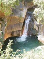
The trail circumvents the continuation of the canyon from about
70 meters above it, offering a breathtaking view of green wooded
slopes, the flowing canyon, and the waterfall splashing into a
large pool.
Plane vs. Jujube
At the edge of the canyon, the trail
returns to the riverbed, whose banks are now round shoulders
instead of rugged cliffs. The woods thinned out as we descended.
The plane trees were fighting an all-out war with the jujubes
for control of the channel, but the increasingly warm climate
and the dwindling of the water were giving the jujubes the upper
hand.
This segment features impressive
populations of connate Alexanders (Smyrnium connatum, or morit
keluta in Hebrew). It is one of the most beautiful wild plants
in Israel because of the sheath at the base of each flower’s
stem that broadens into a cuplike shield; this plant has even
been cultivated for ornamental purposes. It grows to about a
meter in height and usually springs up between piles of rocks.
The Israel Trail leaves Nahal Amud
for a moment and turns left on a dirt road that crosses the
Parod-Amiad Highway (Road No. 85). There is a barrier against
vehicular traffic, but a gate is open to pedestrians. The trail
returns to Nahal Amud at its meeting point with Nahal Achbara.
Lower
Nahal Amud
From here on, we walked along a dirt
road used by herdsmen who graze their cattle in the area. For
about 4 kilometers, the channel digs its way between erect
limestone cliffs. Vultures nest on these cliffs, though a recent
survey by the Birdwatching Center revealed that their numbers
have diminished.
The National Water Carrier crosses
the riverbed here, with the network of pipes that descend from
the northern cliffs and ascend the southern slope camouflaged in
concrete.
About 20,000 years ago, the erosion
that created Nahal Amud began to accelerate, leaving several
caves suspended on the cliff. In 1925, they were the scene of
the first prehistoric research in the Land of Israel, when
British archaeologist Francis Turville-Petre excavated there. In
one of the caves, he discovered forehead bones of what became
known as Galilee Man, estimated to be over 230,000 years old.
We soon reached the pillar (amud)
that gave the riverbed its name – a column of rock about 30
meters in height, which remained in the area after the rocks
around it were swept away.
In the 1960s, in the adjacent cave,
Japanese archaeologists discovered a complete human skeleton
from
the Early Stone Age. Scientists
were divided as to whether it was
from a Neanderthal society or an “advanced” Neanderthal society.
Researchers from the Hebrew
University of Jerusalem, Tel Aviv University, and the Institute
for the Study of Human Origins (at the time in Berkeley,
California) believe the question was resolved when their
excavations in the cave in 1992 unearthed the skeleton of a
10-month-old infant, whose skull fragments convinced
them that a Neanderthal society
dwelled in Nahal Amud.
There is no dispute as to the
identity of the car that waited for us beside the approach road
to Kibbutz Hukuk: it was definitely a Neanderthal vehicle.
Nevertheless, it brought us home safe and sound, after a great
day of hiking. |