|
|
|
THE CHARMS OF NAHAL
MEITZAR
|
|
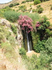
A small stream and
lush green slopes make this an ideal place for a family hike |
|
Nahal Meitzar is the largest of
the riverbeds that run from the southern Golan Heights to the Yarmuk Valley.
Growing on its slopes is a wonderful park forest with a combination of
Mediterranean and desert plants. In winter, the slopes are covered with green
and in spring they are carpeted with beautiful flowers.
The name Meitzar describes the
narrow bit of land that separates Nahal Meitzar from Nahal Ein Gev, which flows
into the Sea of Galilee. Route 98 passes though this area, connecting Kfar Haruv
with Afik. Locals refer to the riverbed as Wadi Yakutza and Wadi Masoud (Arabic
for “Happy River”).
The riverbed begins beside
Khirbet el-Yakutza, about a kilometer from Kibbutz Meitzar. It then descends
westward, digging through mountains and soft rock for about four kilometers
before Wadi Barbara (Arabic for “Noisy Riverbed”) flows into it. Two kilometers
from there, the upper border highway crosses it.
Hikers can continue along the
slopes for another half kilometer to the Nahal Meitzar waterfall. The riverbed
continues for four kilometers from here, carving into the rock and forming
shallow pools, before flowing into the Yarmuk. |
|
The Hike |
|
A few eucalyptus trees and a
small cow pen mark the starting point of the hike, three kilometers southwest of
Afik Junction. The trail passes through a gate and continues to an open plateau,
between thorny bushes of lotus jujube.
Before starting down the steep
decline, on the edge of the slope above the riverbed, take a 50-meter detour to
the left to the lookout point, for a view of the lovely forest of Mt. Tabor
oaks that covers the surrounding slopes. Then follow the trail down the steep
slope to Wadi Barbara.
The trail crosses the river and
continues along Wadi Barbara’s southern bank. Wadi Barbara joins Nahal Meitzar
at the bottom of Ras a-Hatzamtza, a large hill. From here, the banks are covered
with willows and the surrounding slopes with Mt. Tabor oaks. A short distance
further, you will come to a gigantic oak tree. The trail approaches the
riverbed, and then curls toward the highway. From there, descend to the left
into the parking area where, hopefully, a car waiting for you.
But this is not the end of the
hike. Continue on the trail along the slope on the riverbed’s right bank for 15
minutes to a lookout point with a view of the beautiful Nahal Meitzar waterfall. |
|
Route: A
moderate hike along the slope of a riverbed. The trail is marked in blue.
Best Time:
Winter and spring. Do not hike here in summer during the hot part of the day.
Start: 3 km
southwest of the Afik Junction, alongside Route 98 between kilometer markers 21
and 22.
End: Where
the river meets the upper border road.
How to Get
There: Take the approach road to Kibbutz Meitzar, pass the kibbutz, turn
right at the junction, and continue to some buildings used by the army. Turn
right onto a road beside a short row of cypresses. The road is in poor
condition, but navigable in any vehicle. It leads down to a parking area beside
Nahal Meitzar.
Length of Hike:
3 kilometers.
Map: Golan
& Hermon Trail Map 1.
What to Bring:
Comfortable hiking shoes, water, and a hat.
Be sure to
arrange for a car to pick you up at the end of the trail.
|
|