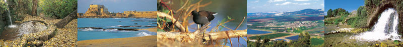
|
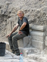
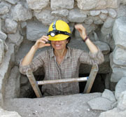
Professor Arthur Segal, Head of the Susita Project
Cistern under one of Susita's eight Byzantine
churches
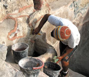
Ancient winery complex
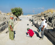
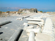
The Decumanus Maximus
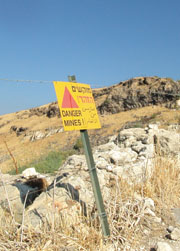
Path to Susita between two fenced off and marked
minefields
The forum
Churches on the Greek temple platform
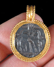
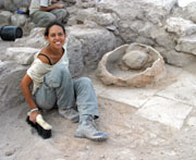
Golden amulet found at Susita |
Let’s say you owned an ancient city, with colonnaded streets, walls
and gates, a theater for plays and a hippodrome for chariot racing,
and temples, churches, and even a cathedral decorated with mosaic
floors. Let’s say your ancient city was perched on a mountaintop
surrounded by steep cliffs overlooking the Sea of Galilee. Let’s say
that this city was connected to the New Testament and mentioned in
the Talmud. Let’s say that the city was destroyed suddenly by an
earthquake and never settled again so that everything was still
there - lying on the ground intact. With all this, would you have
left this city unexcavated, undeveloped? Would you not have utilized
its potential as an amazing visitors’ site? Well, Susita is all this
and if you add its recent history, much more.
In 1990, archaeologist Professor
Vassilios Tzaferis published an article in the Washington,
D.C.-based Biblical Archaeological Review entitled “Susita
Awaits the Spade.” How is it, asked Tzaferis, that no one is
interested in excavating one of the most beautiful and
well-preserved classical sites in the Eastern Mediterranean? Prof.
Arthur Segal, of the Zinman Institute of Archaeology at Haifa
University, decided to take up Tzaferis’s challenge. Segal heads the
Susita Project, and is assisted by Michael Eisenberg. Co-partners in
the project are the Polish Academy of Science, Warsaw, with a team
headed by Prof. Jolanda Mlynarczyk and Dr. Mariusz Burdajewicz, and
Concorde University of St. Paul, Minnesota, with a team headed by
Prof. Mark Schuler.
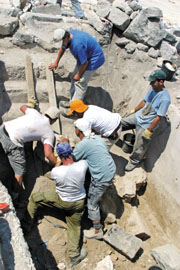
Following a survey of the site in summer 1999, Segal’s team began
excavating in autumn 2004. The discoveries after a mere six seasons
of excavations are mind-boggling. “Susita collapsed in the massive
earthquake of 749 - never to be settled again,” Segal explained as
we sat on the monumental steps of the imperial temple in the city’s
forum. “Everything is still here, just under the surface. All we
have to do is uncover it and put it together again.”
Visiting Susita
An old
untended road leads to the beginning of the path to Susita. To get
to the path you have two options. From the Golan: Turn right at the
Afik junction and drive towards Kfar Haruv on road number 98. 2 km.
down the road, another road branches off to the right. This is the
top entrance to the untended road leading to Susita. Drive carefully
down this road for 4.5 km. until you see a small parking area on
your right - with a green Israel Nature and Parks Authority sign in
front of it. The path to Susita starts here.
The alternative way to get to the path is to enter the road to
Susita from the Sea of Galilee side. The road starts opposite the
entrance to the Ein Gev holiday village (not the entrance to the
kibbutz). It is marked with a large "Do not enter" sign - so that
the Road Works Department will not be sued. Enter at your own peril.
Drive for 3.5 km. up the road. Just before you reach the parking
area, there is a hairpin turn in the road. At this spot, the road
paving has broken up and you need to drive very carefully. Take the
outer edge of the road. After another hairpin turn, you will see the
Parks Authority sign on your left in front of the little parking
area.
Up the Path
The path to Susita is marked in black. It runs along the same ridge
followed by the eastern approach way to Susita. The path runs
between two fenced mine fields (the mine fields are marked - see
photo). Do not deviate from the path.
At the beginning of the path, you are in one of Hippos' two
cemeteries. Notice the carved stone graves strewn all around the
path. As you walk up the path you will see portions of a basalt
stone pipe that brought water via an aqueduct from the springs of
Ein Fik, situated in the ravine far off to your right. The path
enters Susita through the city's eastern gate.
Touring the Town
Susita is not your regulated tourist site. There are no organized
paths, walkways, railings and fences. As you walk down the path from
the eastern gate you are actually walking along the Decumanus
Maximus - Roman Susita's main road. Near the gate some of the basalt
flagstones of this road have been exposed.
About 50 meters from the gate, on your left, is an entrance to a
tunnel. This is a covered trench used by the Israeli forces
stationed here until 1967 - under the Syrians guns on the Golan. The
trench runs through ancient Susita's water system. The tunnel led to
Israel's easternmost bunker, which you walked by as you entered the
city gate. Just under the bunker, the old border marker between the
British Mandate in Palestine and the French Mandate in Syria still
stands.
You can now walk through the tunnel to
the center of the town, or, if old tunnels are not your thing,
continue along the path. Either way you will reach two buildings -
to the left and right of the path. These were the headquarters and
dining room of the Israeli outpost. Even though they were military
installations, great care was taken in order to try and make them
fit into the ancient site. From the verandah of the building on the
left a panoramic view of the Sea of Galilee opens up. Just in front
of the verandah are the remains of Byzantine Susita's cathedral.
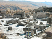
The Forum
Follow the path westward, in the general direction of the Sea of
Galilee. It is unexcavated, dusty, and full of rocks. But 150 meters
along the path you will reach the excavated part of the Decumanus
Maximus. Walk west along the Decumanus to the forum. Dozens of
granite columns are strewn all around. The ones that haven't been
moved are all lying in the same direction as a result of the
earthquake (similar to the columns in the cathedral). At the western
edge of the forum stand the remains of the Imperial Roman Temple.
Just in front of the temple is a huge intact cistern. (The biggest
Byzantine cistern ever found. Take care - don't fall in!) To your
right, on the northern edge of the forum is a large wall made out of
blocks with carved, raised margins. The blocks are laid as headers
and benders (one set lengthways, the other set sideways). This kind
of construction is typical of the Hellenistic period. The wall is
the southern edge of a huge platform on which stood the Greek temple
of Hippos. On top of the platform, two large churches were built as
soon as Hippos turned Christian. After examining the churches (there
are two more further to the east), return to the forum. Now walk to
the Roman Temple at the western edge of the forum and locate the
unpaved road that leads past the right side of the structure towards
the Sea of Galilee.
To the Western Gate
Walk down the road. You are still on the decumanus maximus, a fact
easy to discern by the column bases protruding out of the ground
(the columns themselves are still buried underneath). As you walk
down you will see a large mound on your right. Inside it is Hippos'
theater - still waiting to be excavated. 150 meters further down the
road, on your left, you will pass an old shed - from the Israeli
military days. To you right are the remains of the pulley that used
to pull the supply cable car up the mountain. Past the shed, you
will reach a fork in the road. Take the left fork and continue for
another 50 meters until the road ends. In front of you is yet
another church - the one that was thought to be a synagogue. The
mosaic on the floor is covered with sand.
Back to the Car
From here you can return to the car the same way that you came up -
or cut around the back of the church and walk along the paths in the
general direction of the forum (don't do this if you don't have a
good sense of direction). You are now walking over the remains of
the city - lying in ruin since the earthquake of 749. Walls, stones,
doorways, and lintels are strewn all over the place - waiting for
the excavator to put them together again.
|
Photos:
Michael Eisenberg and Yadin Roman.
Text:
Yadin Roman
ERETZ Magazine
All Rights Reserved 2009 |