|
HIKE
The Scenic View from
Nofit
Nofit is a
flourishing community settlement that is home to some 300 families.
Located on the western edge of the Lower Galilee, on top of a hill that
rises to some 150 meters above sea level, Nofit has a marvelous view of
the riverbed of Nahal Tzipori, the Galilee, and the Acre Valley to the
south.
 A
few residents rolled up their sleeves and turned the service path that
provided access to the community’s sewage pipes into a hiking trail.
They dedicated it to Ohad Zak, a Nofit native who was killed while
serving in Lebanon in December 1998. “Building the trail and the
activity on it connects us to the nature surrounding us,” says Naomi Zak,
Ohad’s mother. “We did receive assistance from Keren Kayemeth LeIsrael-Jewish
National Fund and the Zevulun Regional Council, but this basically is an
initiative of the Nofit residents, who all volunteered their time and
effort. A
few residents rolled up their sleeves and turned the service path that
provided access to the community’s sewage pipes into a hiking trail.
They dedicated it to Ohad Zak, a Nofit native who was killed while
serving in Lebanon in December 1998. “Building the trail and the
activity on it connects us to the nature surrounding us,” says Naomi Zak,
Ohad’s mother. “We did receive assistance from Keren Kayemeth LeIsrael-Jewish
National Fund and the Zevulun Regional Council, but this basically is an
initiative of the Nofit residents, who all volunteered their time and
effort.
“We added benches
and lookout points,” she continues. “We hope to add an ancient oil press
and other antiquities from the Israel Antiquities Authority. The trail’s
steering committee undertook to rehabilitate obstacles and eyesores
along the trail, to clear away rubbish, and to organize educational
activities at the sites along the trail.”
Blue trail markings
were added recently and, since the Israel Trail passes directly below
Nofit, there are plans to connect the two paths.
 A
brown wooden sign reading “Ohad Trail – Around Nofit” marks the
beginning of the path. The garden next to the entrance includes Israeli
wildflowers, such as three-lobed sage and the lentisk. To the right of
the path is an almond orchard owned by a local Bedouin family. A
brown wooden sign reading “Ohad Trail – Around Nofit” marks the
beginning of the path. The garden next to the entrance includes Israeli
wildflowers, such as three-lobed sage and the lentisk. To the right of
the path is an almond orchard owned by a local Bedouin family.
Date, olive,
pomegranate, and almond trees line the first section of the trail that
leads to the “Ladybug Lookout Point.” The children of Nofit painted the
stones here black with red dots, inspiring the name. The lookout point
faces eastward, providing a stunning view of Nahal Tzipori. To the east
are the hills of Nazareth and the Upper Galilee. Stairs descend from
here to the path leading to Nahal Tzipori.
Continuing on the
path around Nofit, we reached a large Mt. Tabor oak (near the phone
line), marking the point from which we could have descended to the
Israel Trail. Hikers on the Israel Trail who are in need of water and
provisions may want to take a detour up to Nofit and visit the local
store.
We decided to name
the next lookout point, which faces north, the “Alil Hill Lookout
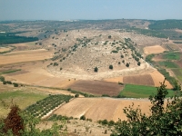
Point,” since it is directly opposite this special hill. The view here
is not only beautiful, but also educational. It provides a lesson in
geography. Alil Hill (or Ras Ali in Arabic) is almost completely
encircled by Nahal Tzipori. Its only connection to the outside world is
the saddle joining it to the hill upon which Nofit sits. The remains of
two abandoned flour mills can be seen near the saddle. The Tzipori
Forest completes the scene. An ancient oil press will be installed
nearby.
The path changed
soon after this. This segment was chiseled into the rock by hand – a
safety rail protects hikers. Mediterranean trees grow along the corridor
to the left of the path. Next, we passed a colorful bench and then a
sundial built by the children of Nofit. From here, we had a great view
to the west of the Carmel, the Nesher quarry, and the Haifa bay
industrial zone. We rapidly reached steps leading to the Nofit sports
center. We made our way around the right side of the basketball court
and were back at the starting point.
ERETZ Staff
This
article
appeared in ERETZ Magazine 103. To subscribe to ERETZ Magazine,
click here. |